Bitte ändert euer Passwort!
Im März 2026 wurde das Forum gehackt. Dabei hatten die Angreifer Zugriff auf die Datenbank und somit Zugriff auf eure Passwörter. Auch wenn das Forum kein Passwort im Klartext speichert, können die Angreifer eure Passwörter knacken. Bitte ändert daher dringend euer Passwort für das Forum. Solltet ihr das gleiche Passwort auch an anderer Stelle verwenden, ändert es bitte unbedingt an allen Stellen!
So geht es:
Anleitung Passwort ändern
GPS data conversion for maps
- Sepp62
- Offline
- Elite Mitglied
-

- Beiträge: 307
- Thanks: 154
Re: GPS data conversion for maps
06 Apr. 2016 15:02
Hi Didier,
I use this app to visualize my GPS flight path:
dl.dropbox.com/u/28579452/TelemetryAnaly...Analyzer-0.1.0.0.msi
My GPS sensor is "selfmade" and it also uses "selfmade" JETI-EX-telemetry. GPS data is logged to my DS-16 as you do it with your solution. Thus, I expect, that the Powerbox GPS will also work with this application.
Unfortunately it is Windows based. There is a JAVA based application from Jeti which is called "Flight Monitor". I do not use it and cannot tell you anything about it. You can find it somewhere on the Jeti web site.
Best regards
Bernd
Folgende Benutzer bedankten sich: Didier
Bitte Anmelden oder Registrieren um der Konversation beizutreten.
- Didier
- Autor
- Offline
- Senior Mitglied
-

- Beiträge: 46
- Thanks: 7
Re: GPS data conversion for maps
06 Apr. 2016 20:06 - 06 Apr. 2016 20:14
Hello Guido, Nico and Bernd.
Thank you very much for all your help guys!
It works!!!!") :lol:
:lol:
It seems that "application is damaged" means that the Mac won't allow you to use "unknown/third party programs".
You can disable this function in the settings of Mac.
Although I have to learn how "data explorer" works, I did manage to see all data of my flights of last monday.
Very cool to see all your sensors and data.
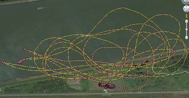
Guido suggested to export the GPS data and import it is Google earth and YES!!!! It works! :lol: :lol: :lol:
Here the screenshot of one of my flights with my Ultraflash. Damn, didn't know I flew that far away everytime.")
Also my topspeed of 420 km/h seems reasonable with a P-160SX.
Once again, thank you all for helping me.
Best regards,
Didier
Niederlande
Thank you very much for all your help guys!
It works!!!!
:lol:It seems that "application is damaged" means that the Mac won't allow you to use "unknown/third party programs".
You can disable this function in the settings of Mac.
Although I have to learn how "data explorer" works, I did manage to see all data of my flights of last monday.
Very cool to see all your sensors and data.
Guido suggested to export the GPS data and import it is Google earth and YES!!!! It works! :lol: :lol: :lol:
Here the screenshot of one of my flights with my Ultraflash. Damn, didn't know I flew that far away everytime.
Also my topspeed of 420 km/h seems reasonable with a P-160SX.
Once again, thank you all for helping me.
Best regards,
Didier
Niederlande
Letzte Änderung: 06 Apr. 2016 20:14 von Didier.
Bitte Anmelden oder Registrieren um der Konversation beizutreten.
- skyfreak
- Offline
- Platinum Mitglied
-

- Beiträge: 2947
- Thanks: 1450
Re: GPS data conversion for maps
06 Apr. 2016 22:11
thx for your feedback nice to know it works
Fliegergruss
GUIDO
_________________________________________________________
Too many dicks on the dance floor.
Too many dicks!
GUIDO
_________________________________________________________
Too many dicks on the dance floor.
Too many dicks!
Bitte Anmelden oder Registrieren um der Konversation beizutreten.
- NicoS
-

- Offline
- Platinum Mitglied
-
- Beiträge: 489
- Thanks: 146
Re: GPS data conversion for maps
11 Apr. 2016 16:33 - 11 Apr. 2016 16:35
Problem solved???
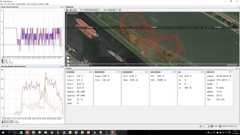
Otherwise I have a solution. The Jeti Flight Monitor works with Windows 10, 8.1 or XP with Java version 7.
But the Flight Monitor do not show te Google Earth map with the flightpad recorded with a PBS GPS
I have adapt my conversion programma and it will convert data from a PBS GPS. Now the Flight Monitor shows the map and the flightpad.
You startet the logging in the Jeti transmitter before the GPS was locked. The flight started in the Atlantic Ocean on GPS location 0,0!!!
If you want, you can have a copy of the conversion program. If so, sent me a PB wit your E-mailadres.
My modelairport is 10 kilometer in a east direction from your modelairport.
Next time we discus in dutch...
Greetings,
Nico
Letzte Änderung: 11 Apr. 2016 16:35 von NicoS.
Bitte Anmelden oder Registrieren um der Konversation beizutreten.
Ladezeit der Seite: 0.586 Sekunden